We live in Narnia. We have such interesting weather here in between the mountains. The original farm here was named “Crosswind Farm”.…
Category
Public
The last time we were in Iceland we took a tour that few people have done. We drove the “Ring Road” on…
I love creative people. “Pipeline Funk”with musician Armin Küpper somewhere in Germany. He has a few more:
Are you a member of “the burn pile”? Left discarded, burned, frozen, trampled, ignored, then snowed and rained on over multiple seasons…
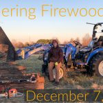
One year later we are doing more of this activity. The wind continues to knock down trees so I go out and harvest the wood which we use to heat our home. Thanks mother nature!
I thought this was interesting. Water is going to be a very big problem at some point in our history as humans.…
On Saturday November 2, 2019 NASA launched an Antares Rocket as a resupply mission to the International Space Station from the Wallops…
For the next month I’ll be out on my motorcycle enjoying the early fall season, change of colors and cooler weather. This…
I’m not an early riser. I’m more likely to arrive at sunrise than start at sunrise. When I do get up I’m…
Lately it hasn’t rained much around here except for the occasional thunderstorm that rolls by. It has, however, been very humid especially…