My day; September 10, 2017

I woke with no specific plan and no place I really wanted to go.

After reading a bit I got up, showered and headed out the door after feeding the cats and eating a light breakfast. Mongrel was all over me to go for a walk so off we went. Like our other walks we stopped at the same trees, inspected everything we’ve inspected before just to be sure and walked essentially the same path as we always do. There’s always something new to see and interesting lights to capture.

Me and my shadow.

Mongrel is content just to be with me. But we’ve got to figure out how to travel in a car together if I am to satisfy his need to be around humans all the time. He’s not a fan of the car.

I ended up in Shepherdstown, WV where I visited with Timothy a little as he played guitar on the steps of the old McMurran Hall. His message is the same; be patient, read the bible, be kind to others, do as Jesus would do.

Timothy with two books: bible and music selections.

I like his guitar sound. But we mostly talked.

On the way home I hung close to the Potomac river and the tiny roads next to the C&O Canal. I stopped at places I normally just drive past to take a few pictures.

Potomac River at 39°23’17” N 77°43’59” W

BTW, do you like the picture above in landscape or this picture below of the same spot but in portrait?

Potomac River at 39°23’17” N 77°43’59” W

I tend to like the landscape photos but this one shows more of the sky and clouds. This part of the Potomac is dammed up south of here near Harpers Ferry that allows people to use normal boats here. There were several pontoons and others mixed with a kayak or two.

C&O Canal at 39°23’17” N 77°43’59” W

The C&O canal extends as far east as Georgetown, District of Columbia all the way up to Cumberland, Maryland. It may go further up towards Ohio but I’m not sure. It’s a long way. You could spend several days on a bike on this if you wanted. It’s said to be slightly declining as you go east. However, when I get on it it is uphill in both directions. I can’t figure that out.

What day would be complete without several ascents into the trees?

Mongrel very focused during his tree acrobatics

Gloria came home tonight from her trip with her mom and sisters. We got to walk together before the sun went down. It was fun to hear about her travel to Cleveland, the restaurants, boat, people and other stories. She let me try to take some portraits of her.

Weary traveler back home – I love her smile.

I’m trying to teach myself how to augment some of my photography with a flash. Flash photography is something I just haven’t spent much time doing over the years. You wouldn’t think you’d need a flash on a sunny day like today … but it helps when the sun is in the sky like this.

And if I could fit just one more thing into the day it would always have something to do with an RC plane or drone. Mongrel joins me in these 20-30 minutes flying sessions. As I bring the plane in slow for landing he will chase after it like it’s a rabbit. It’s pretty funny to watch.

Mongrel ready for “final approach” and landing chase – the plane sounds like an owl when it flies (very quiet). – Photo credit: Gloria Westerman

I started with no plan and ended up with a full day. It’s dark now. I’ll finish this blog and go down and do radio for an hour or two before I finally give in for he day. I did as many of the things I like to do as I could. I was with as many people that I love that I could. Tomorrow’s a “work day” but I hope it is as interesting as today.

Drive to new places

Today we decided not to follow our normal path on a road less traveled. Instead, we got on a set of roads we’ve never traveled not knowing for sure  exactly how to get to where we wanted to go.

To start we were looking for some lunch in Charles Town, WV at a place we’ve eaten before. We didn’t understand why it was so hard to find until we go there and saw that it was closed. It was Mediterranean food where we’ve only eaten once but it was one of the best meals I’ve had in some time. It’s a bummer to see it go.

We ended up across the street at a diner run by Grandma. All of the comfort foods you could want were under that roof. Even an egg salad sandwich on white toast with fries and a sweet tea. I’m definitely going back there!

Grandmas’s Cafe

We set out for “Sleepy Creek Lake” in West Virginia to see what is there. Maybe a place to camp, take some photos, scope out some new motorcycle roads. It’s not far from home. The roads between home and Charlestown are well traveled for us. Beyond that it was all new to us.

Yesterday I put a 50mm lens on my camera to play with depth of field. This is something I haven’t done in some time and want to relearn. The lens I have is super nice and lets ton of light in to play with. Unfortunately, it taught me some lessons that I’m going to have to pay closer attention to. In this panoramic view of the small lake you can see the focal point is in the center of the lake but I had it so tight nothing beyond that in the background or foreground is in focus. Oh well, next time I’ll be more careful.

Playing with depth of field

On the way to the lake we randomly came upon a grass air strip that was also home to the local RC flying club. We turned in to find two gentlemen taking a break from flying their gas powered scale aircraft. It’s a ton of well groomed land and apparently a very active club. Something to check out It’s called the PropBusters RC Airplan Club.

RC Airport and home to PropBusters RC Club.

I was headed out to take pictures of the sun going down tonight and saw this plant on the table reaching for the last rays of the day. I really don’t know what kind of plant this is but it has very long arms reaching as far out as it can to soak up all of the sun’s rays.

Solar power

Speaking of sunsets, the sun was very harsh today in a mostly clear sky. In order not to get a totally washed out image I had to pull the “stand behind a tree for shade” trick. Even still, there was a ton of light to deal with.

Sunset

I was about to rotate the wheels on my car when I saw the moon rise in the eastern sky. You can’t do much with a 50mm non-zoom lens so this is all I can do to show the moon today.

Moonrise

Sock joined me for some of my picture taking. Sockies is getting older these days. Not moving as fast as she used to. Here eyes are getting a bit cloudy, she’s missing a tooth or two but otherwise doing OK for a cat her age.

Socks

In that photo you can see the effect of strong depth of field. Her eye are super focused and detailed but everything else is out of focus. That was taken at f2.5 at 1/800th of a second with an ISO of 80. Clearly it’s letting a ton of light end to be able to use these settings. And it’s an f1.4 lens so the focal point can be even that much more narrow. It’s very, very hard to shoot a moving target with this kind of a narrow depth of field.

It was a fun Labor Day holiday. We did as much as we could with the time we were given. We’ve found a new place to get some grub and a few new roads to explore more. Maybe even a place to pitch a tent for the night.

What will we find tomorrow?

Butterflies

Hi girls. This will be a private post.

I was sorting through photographs the last few days and came across this one. It’s just such a beautiful picture to me which has in it so much of what I enjoy in life: quiet days, mountains, summer, cool breeze, flying, nature, beauty, rebirth … the list goes on.

I wasn’t looking for butterflies to image this day. They just happened to be everywhere I looked. I was at this place on Skyline Drive near home when I saw this one just going back and forth on this plant. It appeared to me to be a new butterfly. It’s wings were still unfurling and it seemed to be orienting to it’s surroundings completely oblivious to me. I was able to spend 15 minutes with the butterfly before I moved on and left it there.

This was actually taken with my iPhone. I did that because I thought this butterfly might take off before I had the opportunity to take it’s picture so I didn’t want to grab my camera from the front seat of my car to capture the image. I did ultimately use my big camera and got some amazing photos of this butterfly but this was my first image. Lately I’ve learned that taking the photo is often more important than taking the perfect photo. Never miss that first opportunity! I just put my cameras on “AUTO” and start shooting. If I have time to be an artist … I’ll know when it comes.

Butterfly at Rattlesnake Point Overlook – Skyline Drive

Touch the image and make it as big as the screen you are looking at right now. It’s just such an amazing picture to me I wanted to share it with you. It tells a story of life, of distance, of effort and of purpose. This butterfly didn’t choose this path but I know for certain it is on it’s path, whatever that means for this butterfly.

You three are no different to me. I know the path is not always easy but it is your path.  I hope you spread your wings a little today as you continue to tell your story. Enjoy a cool, summer breeze and if your path takes you to a overlook as beautiful as this I hope you can stop for a while and take it all in.

I’m off to write more of mine.

Papa

PS: This is where I took the photo:

Solar Eclipse 2017

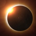
Attending a total solar eclipse was not anywhere on my bucket list a few months ago. A few months ago I decided to put it on my list and attend the solar eclipse that will happen on August 21, 2017.

We are going to be able to take in the solar eclipse on the line of totality in the small city of Andrews, North Carolina. We’ve been planning this trip for a very long time now and set off this morning to go “stare at the sun”.

We’ve planned for a “mini disaster”

We are going to view the eclipse right smack dab on the “totality line” which means for over two full minutes the sun will be completely GONE! That will happen at about 2:36pm on Monday, August 21.

NC Totality Map – Featuring Andrews

We’ll be camping on a ball field in Andrews where the totality line will pass through the outfield of the park. That is where we’ll be camping and viewing the event. I think the only thing we could do better is to be closer to the place on earth that totality will be the longest but that would only gain us about 2 seconds as seen from this map. That is just how close we are to the place that will have the longest totality experience.

Totality length map

The drive down to NC today was like nothing I’ve experience before. We took a route mostly down I-81 which was gridlock at times on this perfectly clear weather day. Tomorrow I hope to capture some of the maps as Google/Waze keeps the route updates with the latest traffic flow information. If today is any indication, tomorrow will be a serious travel headache for many who plan on coming down then. Monday? Forget it!

This is going to be a continuing document.  As I write down my experience I’ll upload all of the details as I have access to the Internet. I’m told by many that where Internet was normally available it might not be available on Monday. Or to even make a phone call for that matter. That being the case, I have brought my radio equipment for both entertainment and in case an emergency really does happen I’ll be ready to figure it out. I also plan on doing some science with radio in the coming days.

It’s Sunday, August 20 now. We left Bryson City around 9am this morning and headed on to Andrews, NC where we’ll be setting up our tent for the night so we don’t have to travel tomorrow to the location where we will be viewing the eclipse.

Part of what I did today was volunteer some time to help the science teacher of the middle school in Andrews explain some radio science that NASA provided to the school. They did hourly presentations on “radio JOVE” which is what I have been helping with.

As I get more information, photos and the like I’ll keep this updated. Right now I’ve completely run out of juice and have to got to bed.

Update: It’s 11:45 and we just got home about 30 minutes ago, unpacked and ready for the day tomorrow. We were on the road today for 14-15 hours trying to get back home in gridlocked traffic jams all the way up to DC. That was after going 74 miles in 3-4 hours yesterday right after the eclipse. I don’t have the energy to stay up all night and then work all day tomorrow so I’ll get with my photography tomorrow.

C1 to C2 contacts points:

Just after C1.
Eclipse through some clouds.
Just prior to totality
Total eclipse of the sun. Andrews, NC. 2:36pm August 21, 2017

More to come… I have to get up at 5:30 to go to work tomorrow.

It’s August 24, 2017, a little after midnight. I’ve been working on some of the time lapse photography today and think I have a sequence going after sorting through 10,000 photos. My computer was acting a bit strange as I worked to sew things together. I’ve finally got a first-cut sequence in the works. It’s taken over an hour so far for my computer to start the process which it’s about 80% through now. I’m going to try to stay up to get to the point of rendering a video and then head on to bed.

I’ve notice that my GoPro camera might be in the process of failing as some of the images didn’t come out perfectly. I think I’ll be able to take some of the images out that didn’t take properly. Some of them were corrected when I cropped the images. When you watch the video you will notice some pink images from time to time. That’s an error in the GoPro camera.

To process the images I use a tool called “LR Timelapse Version 4” I’ve used this program for years. The developer, Gunther Wegner, has kept this software updated and improved over the years. It works in conjunction with Adobe Lightroom to be able to edit the sequence the way you want. Essentially, Lightroom does the heavy lifting for editing enmasse and outputs to LRTimelapse for the sewing of the video. I don’t know how else you’d do something like this and you certainly could not do it easily by hand. 30 years ago, I don’t know how you’d put this together with a film camera either.

Lightroom has the ability to make massive edits to thousands of files for things like lens correction, which is important for a GoPro camera to correct aspect ratios, image quality, size, shape, color correction and similar settings. For example, I can crop the first image to a 16:9 aspect and have all of the other photographs have the exact same cropping.

16:9 aspect is very common. It’s the size and shape of most TV screens and computer monitors. Whereas a 1:1 aspect ratio is good for a photo or video posted on Instagram. I don’t know why Instagram likes square stuff, but ok, whatever. They like you to fit your round objects in their square sockets which is one big reason I don’t like using Instagram for stuff like this. Sometimes my stuff is portrait, sometimes landscape. Most often it’s larger then they allow on their servers. Sometimes it’s not worth the trouble to fit my stuff in their format so it doesn’t get posted there.

Facebook will let you post anything you want in the aspect ratio you prefer but what they won’t do is keep the image quality to it’s original for either a photo or a video.

Back on this video. When I finish the first cut I’ll have to work on the final cuts. For that I use Apple Final Cut Pro which allows me to edit video at scale and add anything I want to it like captions, music and the like. I haven’t figured out what I want to do in that regard yet.

After the first cuts I’ll have to figure out how annoying the bad images are going to be and then go through them one at a time and either edit or remove them. After I do that I’ll have to get a new first cut which will take another 2-3 hours of rendering. As I write this paragraph the process of rendering the first cut for the first time has started.

When this first cut is complete I’ll have to find a place to post it so you can download or view it. That will likely be YouTube because DropBox frowns on that kind of thing and don’t allow embedding like I plan on doing here.

While we wait on that, it’s a good time to mention the Eclipse of 2024. You will need to start planning this event now. Figure out where you want to be in the path of the eclipse. Tilt things in your favor by making sure you are in a place where the weather will cooperate traditionally for you in the area you want to go. For more information on that eclipse you can go to NASA’s web site here. We plan on going!

Helen and Gloria awaiting the eclipse arrival.

Helen and some of her friends came down to join us from college at Virginia Tech University. They set up their tents next to ours on Sunday night and were able to enjoy the eclipse with us.

Staying out of the sun for a while.
Frisbee games in the hot NC sun.
Serious eclipse card games
Friends and family; and a sweet old dog.
Who owns whom?

While we waited for the eclipse to arrive there was much tale telling under our shade tent. My only regret was not taking more actual video of people talking, especially during the eclipse, and more photos of just the normal happenings around me. Gloria picked up my professional camera and didn’t know the focus is “manually activated” so a lot of the photos she took were blurry. While they help tell the story I am not going to publish them here.

It’s no surprise to my family but I brought some of my radio gear with me to have while I observed the eclipse. There was a ton of chatter on all of the bands about what was about to happen. We were on a “grid square” of EM85 with a coordinate of 35.20490 -83.81650. I used this coordinate to calculate the exact time of all of the event contact points.

HF Radio, cameras and other stuff I brought with me to observe some science and astronomy.
Dipole antenna system – 20 and 40 meter antennae.

The antenna is built out of common wire I bought at Lowes, constructed in my back yard and tuned to the frequencies I wanted to operate. It worked perfectly for what I was using it for. It’s not like my other station antennas that are very high off the ground for maximum effectiveness but it worked just fine. I made many contacts in the 0-3500 mile range just like I expected I would.

Here is the first cut of a time lapse from my GoPro:

The idea was that I would capture everything going on around us. There was a flurry of activity before, during and after the eclipse. During the eclipse everyone cheered, shot off fire works and otherwise celebrated the event. That was a ton of fun. As soon as totality was over people started packing up and heading out!

We were also able to capture the “Shadow Bands”. Shadow bands are thin, wavy lines of alternating light and dark that can be seen moving and undulating in parallel on plain-coloured surfaces immediately before and after a total solar eclipse. They are caused by the solar crescent thinning to a narrow slit, which increasingly collimates the light reaching Earth in the moments just before and after totality.

I think it’s fun that at some point the camera was thrown into the sheet, probably unconsciously, to watch everything going on around us.

We didn’t. We packed up slowly and planned to load up the car and head into Andrews for some dinner while the traffic bled off a bit. We could tell it was going slow on the road so we thought we’d let it loosen up. Little did we know that in the next 24 hours it will be very difficult to get back home.

After we has some dinner, packed up the car, motorcycle and trailer we took off from Andrews and headed out the only real road out of town towards Asheville. We thought the traffic would have thinned by the time we got on the road hours after the eclipse where all the eager types had blazed the trail in front of us. It was a good plan anyway.

But that plan didn’t work out. After 4 hours and being rerouted by Waze several times we were in Maggie Valley only 74 miles towards our destination in Northern Virginia. We decided to stay the night and let the traffic continue to bleed off. We thought that was a good plan.

But that plan didn’t work out either. Traffic was pretty good through Asheville and on to I-26 north but the second we got on I-81 our luck changed. The traffic was essentially gridlocked from the intersection of I-26 and I-81 all the way home although we wouldn’t learn the latter until well into the trip north.

Our plans just kept changing as we tried to make it all the way home. At Blacksburg Waze routed us again through the city of Roanoke which even I knew that plan was not a good one. So we got off the main path and headed west towards route 219. SR219 is a goat trail best driven by a motorcycle but we were in a car pulling a motorcycle so we made the best of it. There was very little traffic on the road between Blacksburg and I-64 where we headed east to SR220.

From there it was north towards WV SR48 where we got back on to I-81 into guess what? Yep, grid lock traffic. It was slow going until we got off to SR7. The rest of the trip was uneventful but we were beat tired.

I have to get up in the morning at 5:30am to attend meetings all day in Baltimore. 5:30 will come early.

And all of the logistical nightmare was worth the 2.5 minutes of totality. I’d do it all again tomorrow if there was an eclipse featuring solar totality. We have our sights set on 2024 for the next total solar eclipse.

A solar eclipse wasn’t on my bucket list. It should have been on the short list. I highly recommend you make it to one in your lifetime if you can.

See you in 2024 somewhere on the line that is totality!!

Quiet Sunday

Today would be what I could best describe as placid. Like calm water.

After getting a shower, doing the animal feeding frenzy we call “fandango” around here and getting some work done I set off to go see a new friend of mine in Warrenton, VA just south of my home.

We had a nice long conversation on such a broad set of topics it didn’t take long for a couple of hours to disappear. He’s a ham friend of mine now. It was nice to learn more about him, his family and his love of animals.

When I got there the first thing I noticed was all the monarch butterflies. They were everywhere. And I could walk right up to them and touch them, take pictures of them and otherwise be with them and it didn’t bother them a bit.

Butterflies in Warrenton, Virginia.

The butterflies were all different size, shapes and colors.

Then I drove to the Shenandoah mountains and what did I find?  Yep, more butterflies. With the same behavior. I could get right up next to them without issue. Although this one seems like it’s a brand new butterfly.

Brand new butterfly?

I’m just doing my normal south-to-north “backwards” drive up Skyline where I stop at all my favorite places. Hogback overlook is one of them because of views like this.

Hogback overlook on Skyline Drive – the view just never gets old.

You can click on any of the photos to enlarge them.

It was a nice day to be out in the country.

Summer 2017 Vacation – July 29 – Day 10

Today we visited a place that I’ve wanted to see for a while. Since we started planning this trip to Ruidoso there was a place on the map just southwest of there indicating a national “monument”. White Sands National Monument is the place I wanted to see.

I didn’t know this but there is a difference between a national monument and a national park.

National monuments, are areas preserved by the National Government because they contain objects of historic, prehistoric, or scientific interest. Generally established by presidential proclamation under authority of Congress, occasionally these areas also are established by direct action of Congress.

National parks, on the other hand, are areas set apart by Congress for the use of the people of the United States generally, because of some outstanding scenic feature or natural phenomena. The principal qualities considered in studying areas for park purposes are their inspirational, educational, and recreational values.

I wish I would have asked if I can fly my drone there but didn’t. The rules for drones are in monuments are the same as parks. It’s still odd to me that they will allow someone to ride a dune buggy in the sand but I can’t fly a drone there. It’s likely I could have applied for a permit but I didn’t think to do that in time but something to think about in the future. Anyway…

Getting there you get a sense that something is different about the place. We came from Ruidoso to White Sands National Monument via SR 70 which, at some point, gives you a bit of a view of the desert then it disappears again as you get closer.

You drive through some pretty countryside but sort of “uninteresting” topology because it looks like everything else you are coming through. There are probably some very nice places there.

We entered the facility from SR 70 into a parking lot where the temperature there was over 100º. You know it’s hot but the heat isn’t as bad as if it were here in Virginia with 90% humidity. It’s drier out there.

We do the obligatory stroll through the very small museum-ish kind of place and then the gift shop were we bought a few small things. Then back in to the car and on into the park we go.

There is a two lane route that takes you into the interior of the park. Initially it just looks like any other desert with yucca plants and such in brown sand. But then it changes to a very high contrast white sand landscape.

We noticed people buying toboggans to “sled” on the dunes which I though was sort of odd. With nothing to erase the sand from you skin and clothes (water) it seems it would be uncomfortable to get that all over your body. Everybody has different entertainment needs. Sand stuck in my nether-regions is not one of mine.

As we get in to the park we notice that people are treating it as a camp site, a place to get some sun (as in a beach with no water), horse trail, dune buggy playground, hiking trail, etc.

I mainly wanted to see the park and I was likely to take a picture or two. I wasn’t prepared for the contrast of bright white sand and blue, blue skies.

Gloria and Olivia in the white sand desert

Frankly, it’s a bit overwhelming.

Gloria and Olivia at White Sands National Monument

It was fun to spend the day with Olivia and Gloria. Our time together seemed to go by too fast. It’s seriously hard to believe but tomorrow we will both be apart again.

I don’t like that.

After our visit to White Sands we headed back to Alto, cleaned up and headed over to the Flying J Ranch for dinner and entertainment. While we were there we took some family pictures.

Westerman Family

It’s a motley crew.

The Flying J is good fun. There were some bad guys that came into town that had to be dealt with. Then there was dinner served “chow line” style followed by some music. They served many hundreds of people in 20 minutes. They are very organized there.

We headed on back to the house a little early to pack for the trip home in the morning. Hard to believe the trip is about over.

Summer 2017 Vacation – July 26 – Day 7

Gloria was up before the sun this morning to head out on her hike. As I write this I regret having not gone with her. She speaks of an easy walk through some amazing, open topology to watch the sun rise in the desert mountains. This is all she could come back with:

Big Bend – Photo Credit: Gloria Westerman

I almost sent her back to the mountain to make it right. But I let it go, we packed our stuff and we were off through the park and on to our next destination.

The drive north is pretty and quiet in mostly flat land littered with some very tall mountains. The road is noisy as hell as it’s partly made of this rocky asphalt as you can see in the photo below. I don’t know what else they make the roads out of down there but they are wicked loud. I had my noise canceling headsets in my ears a lot of this trip.

The road to nowhere

As we came up from the park we ran into the border guards checking to make sure people traveling the road are US citizens. They are on all the roads north of the border there. They asked a simple question of citizenship without checking any ID. Then we asked for restaurant recommendations anywhere near Alpine. They had a bunch of idea.

We ended up eating a very late lunch at the Reata Restaurant where the food was fine but I really don’t think the young wait staff was interested in us being there.

As we went further north it was very clear that the new oil pipeline from Canada is creating not just traffic but oil industry jobs all up and down Texas and New Mexico. Through Pecos, in particular, the traffic was very thick from then on out. This was the only time that the traffic on the back roads was so full that we could not get around it.

We took a “back road” from  NM route 285 over to the “National Parks Highway” and on into the Carlsbad Caverns National Park.

It was our intention in the park to see the bats leave their cave around 8pm but we got there so early that we decided to go through the caverns. It was about 5pm when we arrived. We were literally the last people to go into the caverns. I could see that if there were a ton of people in the cavern it would make that experience totally different. Only 2 elevators that hold maybe 10 people each. They said here could be an hour wait to go both up and down.

We rented those little teleprompter devices that you can punch in a number and get a self-guided tour of the caverns. They are absolutely enormous and it takes over an hour to go through them. I only took this one picture towards the end of the tour. It was with my iPhone which has the poorest optics of all of my cameras. But it’s what I had.

Carlsbad Caverns

The caverns are not that pretty but the hole in the ground is massive and expansive at over 30 miles long. If you have seen a stalagmite in one cave you’ve seen them in this one. But the main room is something like 14 acres so it’s quite large. We only saw a fraction of the cave system while we were there.

After the cavern we tried to see the bats but a massive thunderstorm arrived at the same time as the bats were going to leave. They didn’t want to leave in the rain any more than we wanted to stand in the same. We did not get to experience them. We’ll have to come back.

Although we have no real “plan” things have worked out well for this trip. We have had no problems getting hotel accommodations, finding places to dine, grocery stores and food to eat otherwise. It’s been an easy and relaxing time so far (ignoring the poison ivy, of course).

We left the national park and head north to Artesia where we spent the night. Like most every other night, Gloria is asleep first and I fight it to the end.

We have a new guest at our home.

It’s quiet out here. Normally.

Until recently when we had this animal show up.

Our newest member of the family: Female red shoulder hawk.

She’s a noisy thing. Flying all around the property screeching as if asking for permission to be out of the nest.

We noticed it’s parent building a nest high in one of the tall trees in the background back in the spring. In the past week her downy feathers on her underside have turned into more stiff feathers. She’s still very noisy which I don’t think is going to change much in the coming weeks.

It’s been fun watching her in the binoculars. She’s quite the hunter. I’ve seen her with my own eyes catch a rabbit with the aid of both of her parents. If you look closely at her talons you will notice there is blood of some small critter there. Hopefully it’s not from one of our cats!

She moves from tower to pole in what appears to be her new favorite vantage point. We are harvesting the hay today which appears to be giving her unique opportunity to see what might be on the ground.

It’s best not to make any sudden moves if you are a small furry critter. As evidenced by this video.

It’s best to be a fairly large mammal with her around. A “furry mammal” as Helen told me when she was little.

She is a very active hunter and fun to watch do her thing.


zw+pmaJNskHHBg2VM8VY5732OaxKiJTQspnSrULZIUVrja9MEQJy6BvQt3ViSlV8v+QhbXYqC58IlOizDUE6B9XxYa6ngkSkKa6zIaT63wAAm7/rLjn7GCu/6DzfU8Z+WlOo9LA5ufGW7K5KVuMCVT8zW9ELvm0mexBDVdhX4hIL19JYRBXPTvvvkWw1LYrTwemxxikj62DsC1wE6IPmrVo/HT69ImyXh00/0J0qpsrPp39yx4/mwvQ=

Photography

YouTube has really changed the way I look at creating. There are so many people with so many different perspectives who put their thoughts and ideas out there for everyone to use.

One of those people is Mic Bergsma. Mic is apparently deaf but you can not tell. I watch everything Mic puts out because our lives parallel in so many ways. The latest is his review of a gimbal for a regular DLSR camera. There are gimbals out there for speciality cameras and small cameras but this is the first I’ve seen of a gimbal that will work with a regular camera that is heavy with its lens attached.

Mic’s been a big help in my world. I appreciate everything he does and how he does it.

Not sure how much this crane costs but it’s something that would be nice to have in my tool bag.

To my family: zw+on75VskLJFxLULsdY6r2jbuNvyYPY